Latest Gear Live Videos
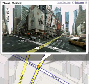
Google Street View comes to iOS web app

Posted by Ponzi Black Categories: Apple, Google, Internet,
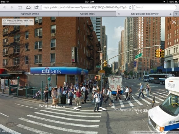
iOS 6 and iPhone 5 users now have a popular Google Maps feature available to them again--Street View. Google Street View is available in the Google Maps web app in Mobile Safari, as well as in the Chrome app. Users can save the web app to their Home screen for quick access to Google Maps. Not as elegant as a native app, but definitely usable.
Advertisement
TeleNav shows off HTML5-powered GPS app

Posted by Andru Edwards Categories: GPS, Internet, Software,
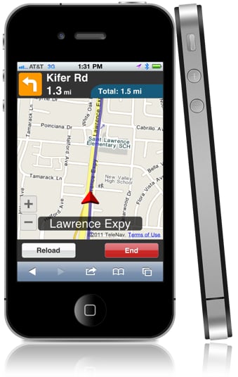
TeleNav, the GPS software company, has unveiled a browser-based HTML5 app that will deliver voice-enabled, turn-by-turn GPS navigation on almost any mobile device—and that other sites can call up with a single line of code.
The concept behind the app is similar to that of Amazon Kindle Cloud Reader: You input the URL and then run TeleNav from within a browser, without installing a native app first. An added benefit: TeleNav can continuously update the service over time whenever it wants, without inconveniencing consumers with periodic software updates.
In an e-mail to us, Mary Beth Lowell, TeleNav's associate director of public relations, confirmed that the HTML5-based app will tap into each device's GPS chip. The combination puts it several leagues ahead of Google Maps, which provides directions without voice prompts, meaning you can also use it in a car while behind the wheel, since you don't have to look at the screen for the next step.
"For example, if I'm in a travel app and I'm looking at my hotel address, I could click on the address and get full voice-guided TBT [turn-by-turn] directions to the hotel," Lowell said. "I wouldn't need to be a TeleNav customer or even download an app."
Click to continue reading TeleNav shows off HTML5-powered GPS app
NASA and ASTER Make New Topographic Map

Posted by Sheila Franklin Categories: Cameras, Science,
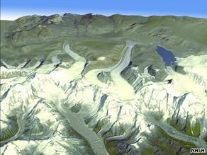 NASA and Japan have teamed to give a better view of the planet. Working with Japan’s Ministry of Economy, Trade and Industry, the US space agency made a digital topographic map with 1.3 million images taken by the Terra satellite with the Japanese ASTER (Advanced Spaceborne Thermal Emission and Reflection Radiometer) and were then pieced together. The map covers more than 99% of Earth’s land mass and fills in details that may have been missed by the space shuttle Endeavor alone.
Read More  | CNN
| CNN
Mapmotive Facebook Application
Posted by Sheila Franklin Categories: Internet,
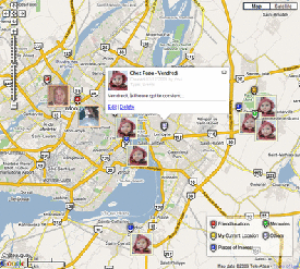 Mapmotive is a handy mapping tool for Facebook that lets you know where your friends are located. Still being worked on by designer creator Jonathan Dunn from Montreal, QC, you can add and share locations of interest, special events and your favorite haunts. Of course it will not work for certain privacy levels, but it would be a fun way to find out where your buds in Oshkosh or Fargo hang out.
Read More | Mapmotive
Alpine Electronics PND-K3 GPS
Posted by Sheila Franklin Categories: GPS, Transportation, Wireless / WiFi,
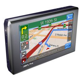 Alpine Electronics usually creates automobile audio/video gadgets and speakers, and now they are going further into GPS territory with their PND-K3. It features an updated interface from their BlackBird II, text-to-speech ability, integrated Bluetooth, and comes preloaded with Navteq maps of the U.S. and Canada with about 6 million points of interest. It has a 4.3-inch touchscreen, an SD expansion slot, customizable map and menu colors, and carries an MSRP of ~$550.00.
Read More | crave
EveryScape Goes Beyond Google Maps
Posted by Sheila Franklin Categories: Cameras, Corporate News, Internet,

A Massachusetts online company has released the beta Everyscape that takes Google mapping an extra step. When you hit their site, you click on a location and see not only the outside but the inside of tourist attractions, musical venues, museums, etc. Click again and you can get detailed info.
“While Google has focused their technology on building a better map, we wanted to do more and replicate the experience of actually being somewhere,” chief executive Jim Schoonmaker said.
The work is being done by “destination ambassadors” that use specialized equipment to map by the mile. It’s a nice idea that seems like it has a long way to go.
Read More | ABC News
Mio Knight Rider GPS System
Posted by Sheila Franklin Categories: GPS, Home Entertainment, Transportation,
 If you can’t afford the real KITT, Mio has developed the Knight Rider GPS unit with voice prompts from the original man behind the car, William Daniels. (You thought we were going to say Hasselhoff, didn’t you?) The LCD displays red LEDs, similar to the car’s front lighting. Among other comments, after powering up it will ask, “Hello Michael. Where do you want to go today?”
Too much fun, especially if your name is Michael. The Knight Rider is expected to carry a $270.00 price. Contact Mio for further details.
Read More | autoblog
Schmap Mapping for iPhone and iPod touch
Posted by Sheila Franklin Categories: Handhelds, Software,

Schmap has come out with a new beta service for iPhones and iPod touches similar to Google mapping. When you hold your device vertically, it features places of interest on a scrollable list which is updated dynamically. Rotate to landscape and it shows them on a map. Tap a name from the list or one of the icons to get more information such as location and phone number with pics. Touch previous or next and you get your choice of other places in the area. Contact Schmap on your iPhone to try out their service.
Read More | Schmap
RoboCup Rescuers Work through Mazes
Posted by Sheila Franklin Categories: Misc. Tech, Science, Videos,
Bots recently competed in Germany as part of the RoboCup to be held in July in China. A sub-competition, RoboCup Rescue, allows robots to practice on dolls in such critical situations as chemical spills and other disasters. Robotic teams must go through a maze and scores are based on how well they can navigate and generate a 3D map of the course. A Manipulation Challenge gives extra points for delivery of radios or water bottles to victims. Currently, it takes about 5 to 10 minutes to scan the area and the same amount of time to create the image, but that should decrease as the bots become more advanced.
Read More | New Scientist Tech
Do Google Maps Invade Privacy?
Posted by Sheila Franklin Categories: Editorial, Google, Transportation,
A Pennsylvania couple is suing Google for invasion of privacy and mental distress. Aaron and Christine Boring claim that the reason they bought their property in the first place was because it was isolated and now it has been devalued. It seems that Google may have taken a street view shot from their driveway that was marked “Private Road.”
Google spokesperson Larry Yu claims that if the pair wanted the images removed, all they had to do was ask. Attorney Dennis Moskal said that their privacy was already hampered when the vehicle that took the shots drove on their property. It will be interesting to see if this has ramifications down the road. While Google maps increase in imaging technique, Big Brother surely gets closer every day.
Read More | MSNBC