
Find Our Latest Video Reviews on YouTube!
If you want to stay on top of all of our video reviews of the latest tech, be sure to check out and subscribe to the Gear Live YouTube channel, hosted by Andru Edwards! It’s free!
Thursday August 3, 2006 5:20 pm
Sony GPS Device Plots Digital Image Locations
Posted by Nino Marchetti Categories: Cameras, GPS
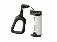 This has to be one of the more unusual devices to come out from Sony in a while. It is the GPS-CS1, used to plot digital images taken with a camera to a map so one can remember exactly where they’ve been.
The GPS-CS1, according to Sony, is priced at around $150 and should be available next month. The 12-channel unit is 3½” inches long and comes with a carabineer to attach it to something so it doesn’t get lost. As Sony explained, the device works by importing “the logged data from the GPS device, using the supplied USB cable, and then downloading the digital images to a computer. The supplied GPS Image Tracker software synchronizes the images on your digital camera with the latitude, longitude and time readings from the GPS-CS1 device. Once synchronized, your photos can become virtual push pins on an online map by activating the Picture Motion Browser software bundled with the latest Sony cameras and camcorders released after July. You can easily add new photos and coordinates to the mapping web site, courtesy of Google Maps.”
Read More ![]() | Sony GPS-CS1 Press Release
| Sony GPS-CS1 Press Release