
Latest Gear Live Videos
NASA and ASTER Make New Topographic Map

Posted by Sheila Franklin Categories: Cameras, Science,
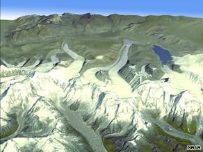 NASA and Japan have teamed to give a better view of the planet. Working with Japan’s Ministry of Economy, Trade and Industry, the US space agency made a digital topographic map with 1.3 million images taken by the Terra satellite with the Japanese ASTER (Advanced Spaceborne Thermal Emission and Reflection Radiometer) and were then pieced together. The map covers more than 99% of Earth’s land mass and fills in details that may have been missed by the space shuttle Endeavor alone.
Read More  | CNN
| CNN
Advertisement
Zoe Makes Maps
Posted by Sheila Franklin Categories: Design, Misc. Tech, Science, Transportation,
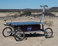 Zoe is learning cartography. The robot contains a hard disk with a basic map with data from ASTER (Astrobiology Science and Technology for Exploring Planets,) an infrared spectrometer on NASA’s Earth Observing Satellite. It works on about a kilometer of area at a time and takes one astral image/second. So far the bot is working on differentiating clay from basalt, with the researchers hoping that someday a similar device could be sent to a planet like Mars, where we won’t be tripping around for quite some time. Zoe has already mastered avoiding obstacles and fair-field sensing, simple for humans, but not for bots.
Read More | Space Daily


Advertisement
© Gear Live Inc. {year} – User-posted content, unless source is quoted, is licensed under a Creative Commons Public Domain License. Gear Live graphics, logos, designs, page headers, button icons, videos, articles, blogs, forums, scripts and other service names are the trademarks of Gear Live Inc.